Bike tours in the area around
Lake Garda starting and ending in Cola di Lazise
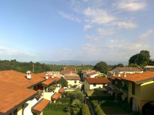
 This homepage has been created for bikers, who live in one of the villages/apartments
owned by Ivan Panizza and Cariza Monuz - Click on the picture or here to visit
the homepage for the villages/apartments.
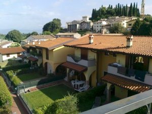
This homepage has been created for bikers, who live in one of the villages/apartments
owned by Ivan Panizza and Cariza Monuz - Click on the picture or here to visit
the homepage for the villages/apartments.
I
have biked all the tours one to three times, but created these routes by two different
mapping programs - "Ride with GPS" or "Bike Road Toaster"
- The total ascent are not the same in the two programs. I have chosen
the amount of ascent from one of them - the one which was nearest my own
measuring.
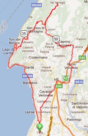
 1. Cola-Prada
- Distance: 74 kms
- Total ascent: 1241 meters
- Maximum Elevation: 1008 meters
The Route:
Cola, Lazise, Bardolino, Garda, Torri del Benaco, Albisano, San Zeno di Montagna, Prabestema, Prada, Prabestema, Lumini, Peagne, Rubiana di Sopra, Rubiana, Caprino Veronese, Montecchio, Zuane Osteria, Rivoli Veronese, Montalto di Sopra, Affi, Pezzo dell'Amore, Cavaion Veronese, Mascanzoni, Calmasino, Rocchetti, Cola.
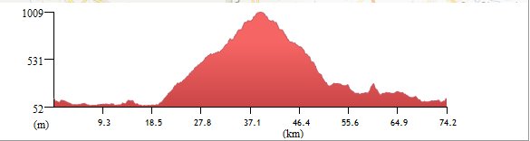
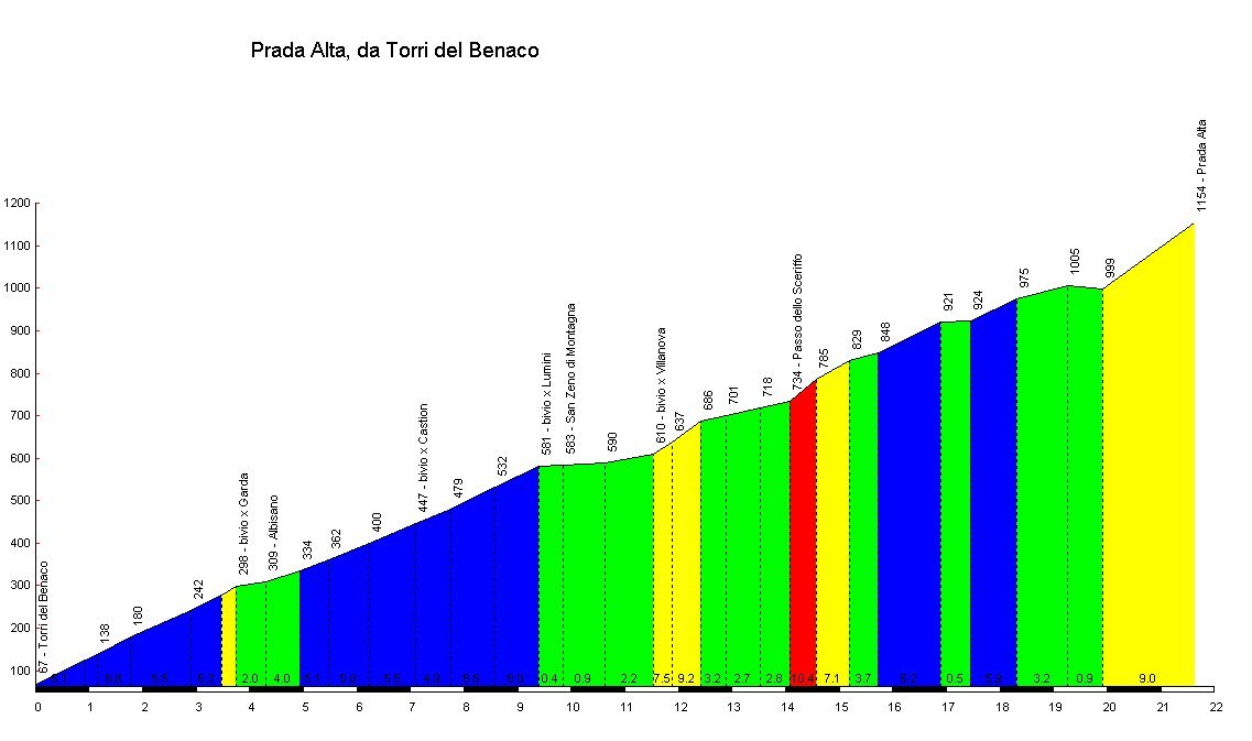
The Profile of Prada Alta:
Click here or on the profile to the right to see the profile only of the mountain
Links to the Route for your Garmin:
- Link to the international website Bike Road Toaster - from where the route can be downloaded.
Click here
At the bottom of this page you will see instructions for downloading routes from Bike Road Toaster to your Garmin
- Link to the international website Bike with GPS - from where the route can be downloaded.
Click here
Use the link Garmin Training Center (.tcx) on the right side of the home-page to download the route to your Garmin device.
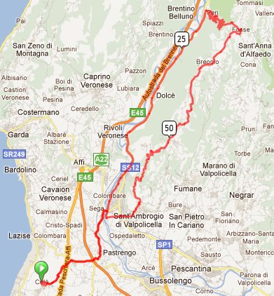
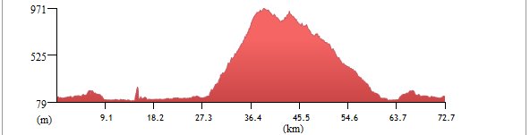 2. Cola-Peri Fosse
- Distance: 73 kms
- Total Ascent: 1275 meters
- Maximum Elevation: 970 meters
The Route:
Cola, Ca'Isidora, Pastrengo, Piovezzano, Sega, Colombare, Volargne, Ceraino, Dolcè, Peri, Fosse, Breonio, Paroletto, Navesa, Verago, Cavalo, Sant'Ambrogio di Valpolicella, Domegliara, Ponton, Sega, Piovezzano, Pastrengo, Ca'Isidora, Cola.
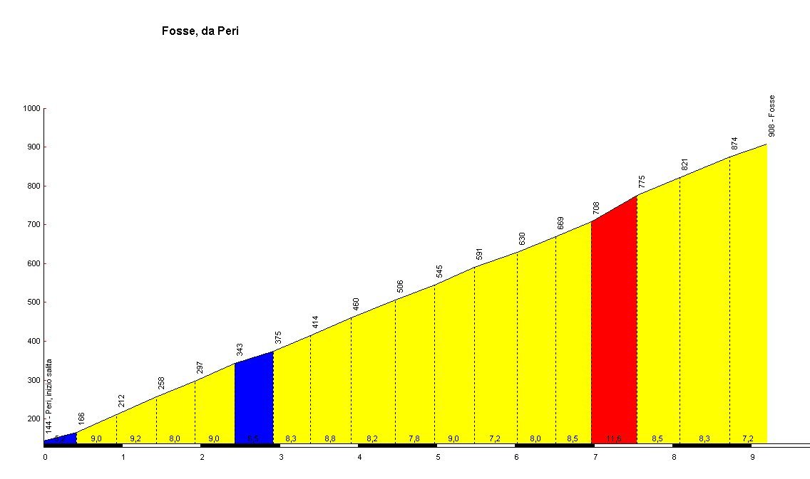
The Profile of Peri Fosse:
Click here or on the profile to the right to see the profile only of the mountain
Links to the Route for your Garmin:
- Link to the international website Bike Road Toaster - from where the route can be downloaded.
Click here
At the bottom of this page you will see instructions for downloading routes from Bike Road Toaster to your Garmin
- Link to the international website Bike with GPS - from where the route can be downloaded.
Click here
Use the link Garmin Training Center (.tcx) on the right side of the home-page to download the route to your Garmin device.
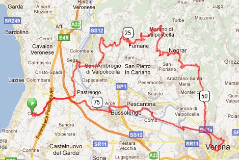
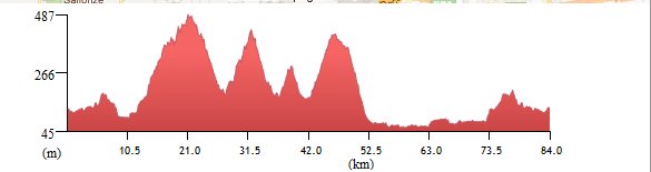 3. Cola-Valpolicella-Verona
- Distance: 84 kms
- Total ascent: 1247 meters
- Maximum Elevation: 471 meters
The Route:
Cola, Ca'Isidora, Pastrengo, Piovezzano, Sega, Ponton, Domegliara, Sant'Ambrogio di Valpolicella, San Giorgio di Valpolicella, Mazzurega, Crocetta, Canzago, Prognol, Valgatara, Negrar, Quinzano, Verona, Chievo, Settimo, Pescantina, Arcè, Bussolengo, Colombarola, Ca'Isidora, Cola.
Links to the Route for your Garmin:
- Link to the international website Bike Road Toaster - from where the route can be downloaded.
Click here
At the bottom of this page you will see instructions for downloading routes from Bike Road Toaster to your Garmin
- Link to the international website Bike with GPS - from where the route can be downloaded.
Click here
Use the link Garmin Training Center (.tcx) on the right side of the home-page to download the route to your Garmin device.
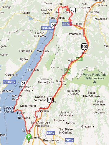
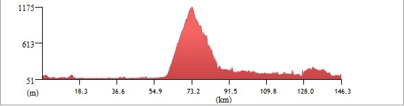 4. Cola-Santa Barbara
- Distance: 146 kms
- Total Ascent: 1744 meters
- Maximum Elevation: 1166 meters
The Route:
Cola, Lazise, Bardolino, Garda, Torri del Benaco, Brenzone, Malcesine, Nago-Torbole, Arco, Bolognano, Santa Barbara, Ronzo-Chienis, Valle Felice, Loppio, Mori, Santa Cecilia, Santa Lucia, Pilcante, Sabionara, Avio, Beluno Veronese, Rivalta, Preabocco, Tessari, Canale, Zuane Osteria, Zuane di Sopra, Affi, Pezzo dell'Amore, Cavaion Veronese, Mascanzoni, Calmasino, Rocchetti, Cola.
The Profile of Peri Fosse:
Click here or on the profile to the right to see the profile only of the mountain
Links to the Route for your Garmin:
- Link to the international website Bike Road Toaster - from where the route can be downloaded.
Click here
At the bottom of this page you will see instructions for downloading routes from Bike Road Toaster to your Garmin
- Link to the international website Bike with GPS - from where the route can be downloaded.
Click here
Use the link Garmin Training Center (.tcx) on the right side of the home-page to download the route to your Garmin device.
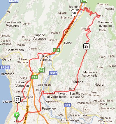
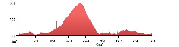 5. Cola-Fosse
- Distance: 78 kms
- Total ascent: 1265 meters
- Maximum Elevation: 970 meters
The Route:
Cola, Ca'Isidora, Pastrengo, Piovezzano, Sega, Ponton, Domegliara, Sant'Ambrogio di Valpolicella, Dante, Fumane, Vivera Molina, Gorgusello, Breonio, Fosse, Peri, Brentino Belluno, Preabocco, Tessari, Canale, Zuane Osteria, Zuane di Sopra, Affi, Pezzo dell'Amore, Cavaion Veronese, Mascanzoni, Calmasino, Montioni, Rocchetti, Cola.
The Profile of Peri Fosse:
Click here or on the profile to the right to see the profile only of the mountain
Links to the Route for your Garmin:
- Link to the international website Bike Road Toaster - from where the route can be downloaded.
Click here
At the bottom of this page you will see instructions for downloading routes from Bike Road Toaster to your Garmin
- Link to the international website Bike with GPS - from where the route can be downloaded.
Click here
Use the link Garmin Training Center (.tcx) on the right side of the home-page to download the route to your Garmin device.
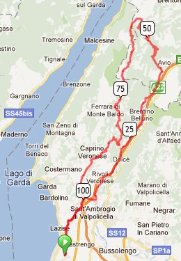
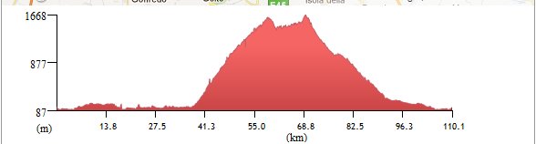 6. Cola-Monte Baldo
- Distance: 110 kms
- Total Ascent: 2083 meters
- Maximum Elevation: 1621 meters
The Route:
Cola, Rocchetti, Calmasino, Mascanzoni, Cavaion Veronese,Pezzo dell'Amore, Affi, Dauzia, Giarette, Rivoli Veronese, Canale, Preabocco, Brentino Belluno, Belluno Veronese, Mama di Sopra, Avio, San Valentino, Monte Baldo top, Villaggio Alpino, Campedello, Spiazzi Bazzega, Maso, Vezzane, Prezzon, San Michele, Caprino Veronese, Ceredello, Affi, Pezzo dell'Amore, Cavaion Veronese, Mascanzoni, Calmasino, Rocchetti, Cola.
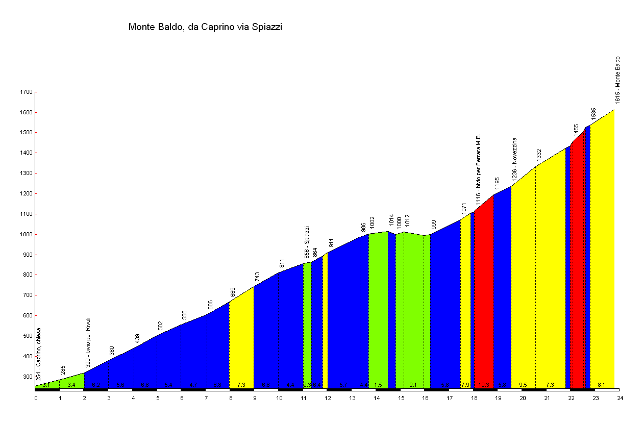
The Profile of Monte Baldo:
Click here or on the profile to the right to see the profile only of the mountain
Links to the Route for your Garmin:
- Link to the international website Bike Road Toaster - from where the route can be downloaded.
Click here
At the bottom of this page you will see instructions for downloading routes from Bike Road Toaster to your Garmin
- Link to the international website Bike with GPS - from where the route can be downloaded.
Click here
Use the link Garmin Training Center (.tcx) on the right side of the home-page to download the route to your Garmin device.
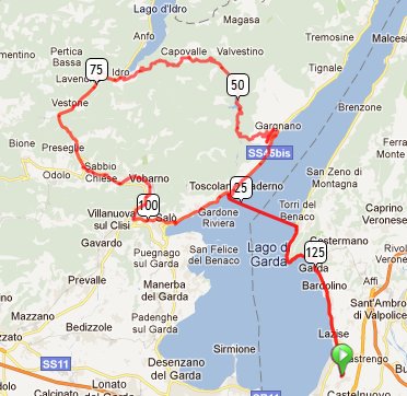
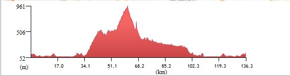 7. Cola-Lake Garda West
- Distance: 136 kms
- Total ascent: 1428 meters
- Maximum Elevation: 931 meters
The Route:
Cola, Lazise, Bardolino, Garda, Torri del Benaco, Toscolano-Maderno, Bogliaco, Gargnano, Navazzo, Lago Valvestino, Capovalle, Lago di Idro, Idro, Lavenone, Promo, Nozza, Barghe, Sabbio Chiese, Pavone, Carpeneda, Vobarno, Pompegnino, Tormini, Trobiolo, Salò, Bornico, Toscolano-Maderno, Torri del Benaco, Garda, Bardolino, Lazise, Cola.
Links to the Route for your Garmin:
- Link to the international website Bike Road Toaster - from where the route can be downloaded.
Click here
At the bottom of this page you will see instructions for downloading routes from Bike Road Toaster to your Garmin
- Link to the international website Bike with GPS - from where the route can be downloaded.
Click here
Use the link Garmin Training Center (.tcx) on the right side of the home-page to download the route to your Garmin device.
Instructions for downloading routes from Bike Road Toaster to your Garmin:
1. Connect your Garmin to your PC, and wait until it is connected
2. Click the link next to the route you want to run
The browser will now open the map with the route
3. click on the tab "Summary"
4. In the box "Download" you write the "Course Name"
5. Mark the box next to "Add Course Point Warnings"
6. Click "tcx" next to "To Garmin GPS"
7. New box will appear - click on "write course" in the blou box
and wait for the message "Data write to the device"
If you have problems with this program - jump to point 6a below
8. If you now look at your "Garmin Folder" under "Courses"
you can see he route file is on your Garmin.
Have a good tour in the area around Lake Garda
Alternative way to download your route from Bike Road Toaster to your Garmin:
6a. Click "tcx" next to "To File". - Now your tcx-file will be downloaded to your folder Downloaded files on your computer.
7a. Now you copy or move your file from this folder to your Course-folder on your Garmin device as you copy or move all other files between folders on your computer.
Visit my Bike-page
From the link above you can see many links to my bike tours in Italy, France, Sweden and Denmark.
Three of them are from tours in the area around Lake Garda
Mail
to bornhardt.dk
November 13, 2011